

Lake Road Lift Station
Proposed Replacement
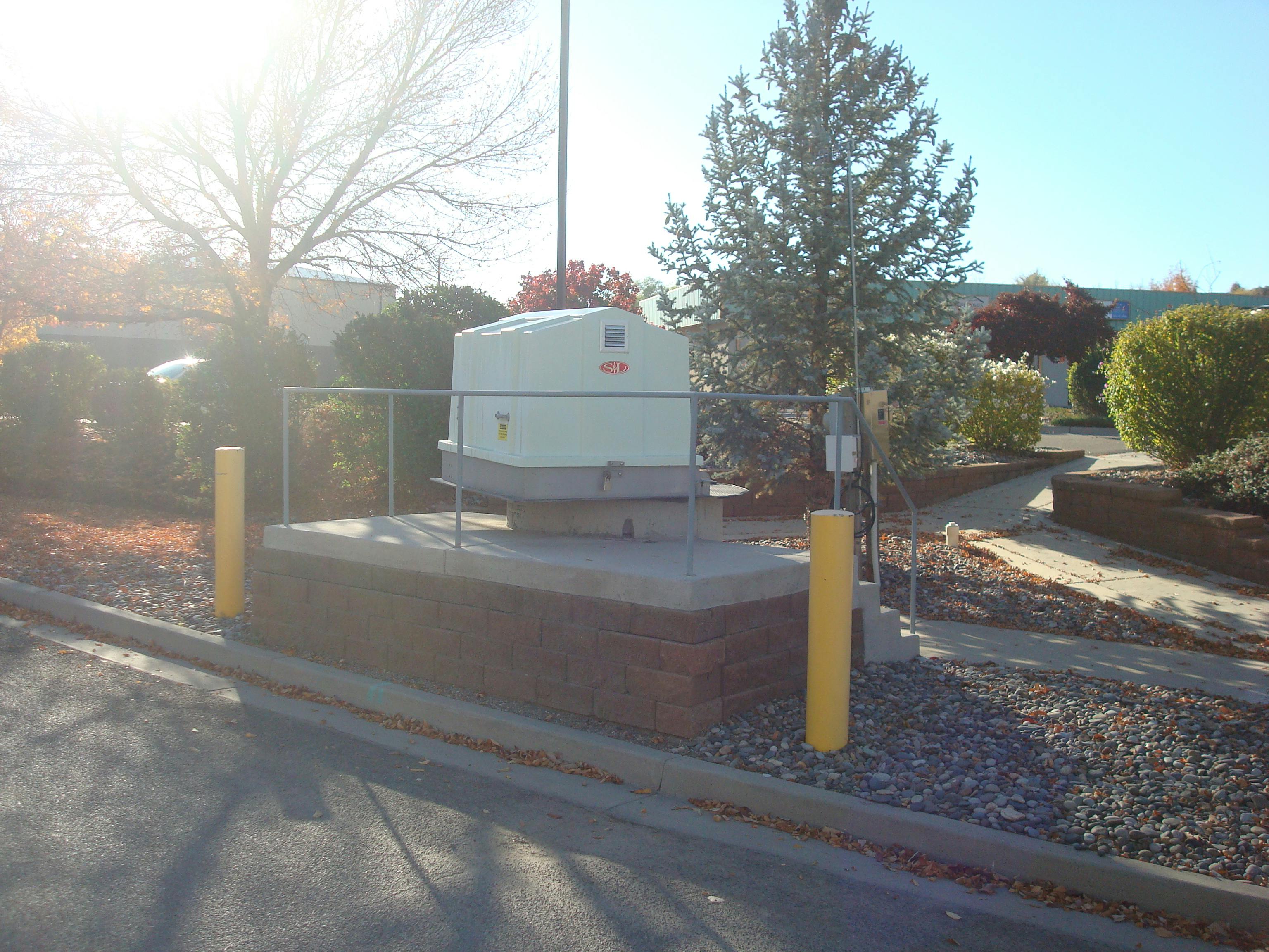
The City of Grand Junction is proposing installing a lift station at Lake Road which will replace the current Ridges and Brach's Market lift stations. The Ridges lift station is nearing the end of its useful life and is located within the high-traffic Broadway (Highway 340) right-of-way which poses both construction and operational challenges. Eliminating the nearby Brach’s Market lift station will reduce system operating costs and by establishing the Lake Road lift station, an opportunity to extend sewer service to areas of Canary Lane, Connected Lakes, and Red Mesa Heights neighborhoods which are designated as sewer improvement districts.
The new Lake Road lift station conforms with current design standards and will have easy access for cleaning operations so it will not have the odor issues of the current Ridges lift station which is not up to current standards. The lift station will pump wastewater from the lower elevation area to a connecting sewer across the Colorado River that then conveys the wastewater to the Persigo wastewater treatment plant on River Road managed jointly by Mesa County and the City of Grand Junction.
Provide feedback in the tools section below about the proposed lift station and a city staff member will respond.
Proposed Replacement
The City of Grand Junction is proposing installing a lift station at Lake Road which will replace the current Ridges and Brach's Market lift stations. The Ridges lift station is nearing the end of its useful life and is located within the high-traffic Broadway (Highway 340) right-of-way which poses both construction and operational challenges. Eliminating the nearby Brach’s Market lift station will reduce system operating costs and by establishing the Lake Road lift station, an opportunity to extend sewer service to areas of Canary Lane, Connected Lakes, and Red Mesa Heights neighborhoods which are designated as sewer improvement districts.
The new Lake Road lift station conforms with current design standards and will have easy access for cleaning operations so it will not have the odor issues of the current Ridges lift station which is not up to current standards. The lift station will pump wastewater from the lower elevation area to a connecting sewer across the Colorado River that then conveys the wastewater to the Persigo wastewater treatment plant on River Road managed jointly by Mesa County and the City of Grand Junction.
Provide feedback in the tools section below about the proposed lift station and a city staff member will respond.
Leave city staff a question about the Lake Road lift station.
-
Share What is the funding source for the proposed irrigation line replacement proposed in conjunction with the sewer line project ? on Facebook Share What is the funding source for the proposed irrigation line replacement proposed in conjunction with the sewer line project ? on X (formerly Twitter) Share What is the funding source for the proposed irrigation line replacement proposed in conjunction with the sewer line project ? on Linkedin Email What is the funding source for the proposed irrigation line replacement proposed in conjunction with the sewer line project ? link
What is the funding source for the proposed irrigation line replacement proposed in conjunction with the sewer line project ?
GASTOUT asked over 2 years agoThe Sewer Enterprise Fund will be used to fund this proposed project and this includes the proposed irrigation line replacement.
-
Share The bank at 238 Red Mesa is slowly sliding into the Redlands Power Canal. This is the same geological bank (less that 2,300 feet away) that the proposed inlet pipeline is routed along. Have any bank stability studies been conducted along this route? on Facebook Share The bank at 238 Red Mesa is slowly sliding into the Redlands Power Canal. This is the same geological bank (less that 2,300 feet away) that the proposed inlet pipeline is routed along. Have any bank stability studies been conducted along this route? on X (formerly Twitter) Share The bank at 238 Red Mesa is slowly sliding into the Redlands Power Canal. This is the same geological bank (less that 2,300 feet away) that the proposed inlet pipeline is routed along. Have any bank stability studies been conducted along this route? on Linkedin Email The bank at 238 Red Mesa is slowly sliding into the Redlands Power Canal. This is the same geological bank (less that 2,300 feet away) that the proposed inlet pipeline is routed along. Have any bank stability studies been conducted along this route? link
The bank at 238 Red Mesa is slowly sliding into the Redlands Power Canal. This is the same geological bank (less that 2,300 feet away) that the proposed inlet pipeline is routed along. Have any bank stability studies been conducted along this route?
GASTOUT asked over 2 years agoThe City hired a geotechnical engineering consultant to complete a slope stability analysis on the existing bank/slope the proposed new sewer line and irrigation line are planned to be located along as shown on sheets C2.4 – C2.6 within the plans. The City expects to receive the slope stability analysis from the consultant towards the end of January 2024. Once this report is complete, the City can provide a more detailed response to the stability of this existing slope.
-
Share Red Mesa Heights and Canary Subdivisions are proposed future connections to the lift station line. What route is proposed for these lines and what is the proposed connection point ? on Facebook Share Red Mesa Heights and Canary Subdivisions are proposed future connections to the lift station line. What route is proposed for these lines and what is the proposed connection point ? on X (formerly Twitter) Share Red Mesa Heights and Canary Subdivisions are proposed future connections to the lift station line. What route is proposed for these lines and what is the proposed connection point ? on Linkedin Email Red Mesa Heights and Canary Subdivisions are proposed future connections to the lift station line. What route is proposed for these lines and what is the proposed connection point ? link
Red Mesa Heights and Canary Subdivisions are proposed future connections to the lift station line. What route is proposed for these lines and what is the proposed connection point ?
GASTOUT asked over 2 years agoThe route of the proposed sewer line alignment that would provide sewer service to the Red Mesa Heights and Canary Lane subdivisions would branch off the proposed Ridge’s gravity sewer line at the sewer manhole located at Station 36+46.93. The sewer line that would serve these two neighborhoods would follow the existing driveway accesses of two residential properties to gain access into the roadway right-of-way of Santa Rosa Lane. From Santa Rosa Lane, the proposed sewer lines would use roadway right-of-ways and sewer easements to serve these two neighborhoods with sewer.
All new sewer pipe will be standard practice gasketed PVC pipe that has to successfully pass pressure/leakage tests before the sewer pipe(s) will be accepted and allowed to be put into service.
-
Share Have any public meetings by City Staff about this project been conducted prior to the November 6, 2023 meeting ? Have the City Council conducted any public meetings about this project? on Facebook Share Have any public meetings by City Staff about this project been conducted prior to the November 6, 2023 meeting ? Have the City Council conducted any public meetings about this project? on X (formerly Twitter) Share Have any public meetings by City Staff about this project been conducted prior to the November 6, 2023 meeting ? Have the City Council conducted any public meetings about this project? on Linkedin Email Have any public meetings by City Staff about this project been conducted prior to the November 6, 2023 meeting ? Have the City Council conducted any public meetings about this project? link
Have any public meetings by City Staff about this project been conducted prior to the November 6, 2023 meeting ? Have the City Council conducted any public meetings about this project?
GASTOUT asked over 2 years agoNo public meetings were conducted before November 6, 2023. No City Council meetings have taken place as there have not been any activities that have required City Council to take action to date.
-
Share The pressurized irrigation line in the same narrow gravel road as the proposed sewer line (Blueprint C2.4-C2.6) has had multiple leaks and repairs. What design / construction considerations are used to protect the proposed sewer line from saturated expansive soil, jetting, damage during repairs to this irrigation line ? on Facebook Share The pressurized irrigation line in the same narrow gravel road as the proposed sewer line (Blueprint C2.4-C2.6) has had multiple leaks and repairs. What design / construction considerations are used to protect the proposed sewer line from saturated expansive soil, jetting, damage during repairs to this irrigation line ? on X (formerly Twitter) Share The pressurized irrigation line in the same narrow gravel road as the proposed sewer line (Blueprint C2.4-C2.6) has had multiple leaks and repairs. What design / construction considerations are used to protect the proposed sewer line from saturated expansive soil, jetting, damage during repairs to this irrigation line ? on Linkedin Email The pressurized irrigation line in the same narrow gravel road as the proposed sewer line (Blueprint C2.4-C2.6) has had multiple leaks and repairs. What design / construction considerations are used to protect the proposed sewer line from saturated expansive soil, jetting, damage during repairs to this irrigation line ? link
The pressurized irrigation line in the same narrow gravel road as the proposed sewer line (Blueprint C2.4-C2.6) has had multiple leaks and repairs. What design / construction considerations are used to protect the proposed sewer line from saturated expansive soil, jetting, damage during repairs to this irrigation line ?
GASTOUT asked over 2 years agoThe City has not experienced any leaks and/or pipeline breaks requiring repairs in this section of the irrigation pipeline between the tailrace canal pumphouse and Highway 340.
As part of this project, the existing irrigation line will be removed and replaced with a new continuously fused 20” diameter HDPE pipeline along the alignment of the proposed sanitary sewer pipeline between Stations 26+67 and 37+57. By fusing the HDPE pipe, the pipeline will be one continuous pipeline with no fittings and/or joints. As such, the City does not anticipate that the new HDPE pipe will leak necessitating repairs.
As the City does throughout the collection system, the City uses state-of-the-art Closed-Circuit Television (CCTV) camera equipment to inspect and monitor for inflow and infiltration (I/I) and alert City staff of possible repairs needed for the sewer joints and manholes and/or for nearby storm, potable water, or irrigation mains.
-
Share The lift station plans show a back up generator on the North side of the building. What is the projected noise level of this generator ? How often will it run ? What is the fuel source ? If a liquid fuel, where will it be stored and what quantity ? on Facebook Share The lift station plans show a back up generator on the North side of the building. What is the projected noise level of this generator ? How often will it run ? What is the fuel source ? If a liquid fuel, where will it be stored and what quantity ? on X (formerly Twitter) Share The lift station plans show a back up generator on the North side of the building. What is the projected noise level of this generator ? How often will it run ? What is the fuel source ? If a liquid fuel, where will it be stored and what quantity ? on Linkedin Email The lift station plans show a back up generator on the North side of the building. What is the projected noise level of this generator ? How often will it run ? What is the fuel source ? If a liquid fuel, where will it be stored and what quantity ? link
The lift station plans show a back up generator on the North side of the building. What is the projected noise level of this generator ? How often will it run ? What is the fuel source ? If a liquid fuel, where will it be stored and what quantity ?
GASTOUT asked over 2 years agoNoise from the diesel generator will be very minimal. The generator will be installed with a noise suppression “Quiet Pack” on the exhaust system to minimize noise. The decibel level for the generator is expected to be about 65 dB, which is no louder than normal conversation. Additionally, the generator will only run for 30 minutes, once a month for regular maintenance, lubrication, and general equipment exercise. The purpose of the generator is to maintain the operation of the lift station during a power outage. The fuel source is diesel which is stored in an integral fuel tank beneath the generator. At this time, the quantity of fuel stored has not been determined. Specifications for engine generators typically require fuel tanks to be large enough to allow for a minimum of 24 hours of continuous engine operation at ¾ load. City staff will refuel with diesel during regular maintenance checks at the Lift Station.
-
Share Red Mesa Heights and Canary Subdivisions are proposed to hook up to the line from the Ridges. What is the proposed route, where would connections be made? Wouldn't these lines only increase the risk of a leak or break to contaminate nearby private ponds that drain into State Waters or drain sewage into the Colorado River? What are the design features to prevent this? on Facebook Share Red Mesa Heights and Canary Subdivisions are proposed to hook up to the line from the Ridges. What is the proposed route, where would connections be made? Wouldn't these lines only increase the risk of a leak or break to contaminate nearby private ponds that drain into State Waters or drain sewage into the Colorado River? What are the design features to prevent this? on X (formerly Twitter) Share Red Mesa Heights and Canary Subdivisions are proposed to hook up to the line from the Ridges. What is the proposed route, where would connections be made? Wouldn't these lines only increase the risk of a leak or break to contaminate nearby private ponds that drain into State Waters or drain sewage into the Colorado River? What are the design features to prevent this? on Linkedin Email Red Mesa Heights and Canary Subdivisions are proposed to hook up to the line from the Ridges. What is the proposed route, where would connections be made? Wouldn't these lines only increase the risk of a leak or break to contaminate nearby private ponds that drain into State Waters or drain sewage into the Colorado River? What are the design features to prevent this? link
Red Mesa Heights and Canary Subdivisions are proposed to hook up to the line from the Ridges. What is the proposed route, where would connections be made? Wouldn't these lines only increase the risk of a leak or break to contaminate nearby private ponds that drain into State Waters or drain sewage into the Colorado River? What are the design features to prevent this?
GASTOUT asked over 2 years agoThe route of the proposed sewer line alignment that would provide sewer service to the Red Mesa Heights and Canary Lane subdivisions would branch off of the proposed Ridge’s gravity sewer line at Station 36+46.93 following the existing driveway accesses of two residential properties to gain access into the roadway right-of-way of Santa Rosa Lane. From Santa Rosa Lane, the proposed sewer lines would use existing roadway right-of-ways and sewer easements to serve these two neighborhoods with sewer.
All new sewer pipe will be gasketed PVC pipe that has to successfully pass pressure/leakage tests before the sewer pipe(s) will be accepted and allowed to be put into service.
-
Share A leak in the line proposed on Blueprint Sheets C2.4-C2.6 would pollute private ponds in the area which drain into Colorado State Waters. A break in the line at full build-out will release 550,224 gallons per day of raw sewage into the Redlands Power Canal / Colorado River. What contingency plans are in place for either scenario? on Facebook Share A leak in the line proposed on Blueprint Sheets C2.4-C2.6 would pollute private ponds in the area which drain into Colorado State Waters. A break in the line at full build-out will release 550,224 gallons per day of raw sewage into the Redlands Power Canal / Colorado River. What contingency plans are in place for either scenario? on X (formerly Twitter) Share A leak in the line proposed on Blueprint Sheets C2.4-C2.6 would pollute private ponds in the area which drain into Colorado State Waters. A break in the line at full build-out will release 550,224 gallons per day of raw sewage into the Redlands Power Canal / Colorado River. What contingency plans are in place for either scenario? on Linkedin Email A leak in the line proposed on Blueprint Sheets C2.4-C2.6 would pollute private ponds in the area which drain into Colorado State Waters. A break in the line at full build-out will release 550,224 gallons per day of raw sewage into the Redlands Power Canal / Colorado River. What contingency plans are in place for either scenario? link
A leak in the line proposed on Blueprint Sheets C2.4-C2.6 would pollute private ponds in the area which drain into Colorado State Waters. A break in the line at full build-out will release 550,224 gallons per day of raw sewage into the Redlands Power Canal / Colorado River. What contingency plans are in place for either scenario?
GASTOUT asked over 2 years agoWe do not anticipate any sanitary sewer overflows from a failure to private ponds because there are various contingency plans and equipment redundancies to maintain continuity of operations. We have a dedicated maintenance team available on call 24/7/365, ready to swiftly respond to any emergent issues that may arise, ensuring consistent operational efficiency. The City utilizes standard gasket PVC sewer pipe that is pressure tested to confirm that it is not leaking prior to acceptance from the contractor and before it is put into service. This is standard practice supported by the American Water Works Association (AWWA) professional practice for the industry. In addition, clay cut-off walls will be installed upstream of sewer manholes to stop the flow of water along the pipeline. Clay cut-off walls help City crews identify potential leaks by visually seeing a wet spot on the ground. In addition, the City employs a state-of-the-art CCTV camera system that inspects sewer lines for conditions and can help identify if there is an issue with a pipe joint that could result in a leak.
This project is expected to yield a substantial positive impact on water quality in the Connected Lakes area over the long term. Approximately 165 homes in the Connected Lakes, Canary Lane, and Red Mesa Heights subdivisions presently discharge untreated sewage into septic systems, ultimately releasing it into the ground near the surrounding ponds. With these septic systems aging and prone to failure, there's a risk of contamination, involving E. coli, chemicals, as well as nutrients like nitrogen and phosphorus seeping into the groundwater and ponds. The Lake Road Lift Station project is believed to significantly enhance water quality in the area by facilitating the future connection of these 165 homes to sanitary sewers. Once connected, their waste will be gathered and conveyed to the Persigo Wastewater Treatment Plant for the highest quality treatment before being returned to the Colorado River. This crucial step will mitigate the environmental impact caused by the current discharge methods, thus promoting healthier and more sustainable water ecosystems in the region.
-
Share Have any engineering / geological studies been conducted on the effect of the 5-6 foot deep trenching in blueprint areas C2.6, C2.5 & C2.4 ? The bank West along this area shows surface erosion both above and below the proposed route, would it be further destabilized by vibration ? on Facebook Share Have any engineering / geological studies been conducted on the effect of the 5-6 foot deep trenching in blueprint areas C2.6, C2.5 & C2.4 ? The bank West along this area shows surface erosion both above and below the proposed route, would it be further destabilized by vibration ? on X (formerly Twitter) Share Have any engineering / geological studies been conducted on the effect of the 5-6 foot deep trenching in blueprint areas C2.6, C2.5 & C2.4 ? The bank West along this area shows surface erosion both above and below the proposed route, would it be further destabilized by vibration ? on Linkedin Email Have any engineering / geological studies been conducted on the effect of the 5-6 foot deep trenching in blueprint areas C2.6, C2.5 & C2.4 ? The bank West along this area shows surface erosion both above and below the proposed route, would it be further destabilized by vibration ? link
Have any engineering / geological studies been conducted on the effect of the 5-6 foot deep trenching in blueprint areas C2.6, C2.5 & C2.4 ? The bank West along this area shows surface erosion both above and below the proposed route, would it be further destabilized by vibration ?
GASTOUT asked over 2 years ago- The contractor will safely perform excavation for this area with trench boxes and other bracing mechanisms during construction and follow the existing road alignment to avoid cross slopes and excessive surface erosion. A geotechnical engineer will be involved throughout construction to observe excavation and testing for backfill material testing.
-
Share What would be the potential cost of a sewer system for Red Mesa Height's individual owners? Assume a tap fee of approximately $4,000. Given that material and construction costs are rising rapidly, would an order of magnitude be $10,000 per property? Would this include the initial sewer main installation, or would this increase the cost to individual property owners? on Facebook Share What would be the potential cost of a sewer system for Red Mesa Height's individual owners? Assume a tap fee of approximately $4,000. Given that material and construction costs are rising rapidly, would an order of magnitude be $10,000 per property? Would this include the initial sewer main installation, or would this increase the cost to individual property owners? on X (formerly Twitter) Share What would be the potential cost of a sewer system for Red Mesa Height's individual owners? Assume a tap fee of approximately $4,000. Given that material and construction costs are rising rapidly, would an order of magnitude be $10,000 per property? Would this include the initial sewer main installation, or would this increase the cost to individual property owners? on Linkedin Email What would be the potential cost of a sewer system for Red Mesa Height's individual owners? Assume a tap fee of approximately $4,000. Given that material and construction costs are rising rapidly, would an order of magnitude be $10,000 per property? Would this include the initial sewer main installation, or would this increase the cost to individual property owners? link
What would be the potential cost of a sewer system for Red Mesa Height's individual owners? Assume a tap fee of approximately $4,000. Given that material and construction costs are rising rapidly, would an order of magnitude be $10,000 per property? Would this include the initial sewer main installation, or would this increase the cost to individual property owners?
GASTOUT asked over 2 years ago- We don’t have a current 2023 cost estimate for the Red Mesa Heights sewer improvement district. If there is sufficient interest from the property owners in the Red Mesa Heights area to connect to sewer, we can schedule a community meeting to discuss this option and prepare preliminary cost estimates.
Who's Listening
-
Wastewater Project Manager
LCPhone 970-256-4155 Email leec@gjcity.org
Key Dates
-
November 06 2023
Follow Project
Signup Banner
FAQs
- Are there going to be more meetings? Are the residents going to be forced to stop using septic tanks and have to use sewer line?
- Is there another parcel of available land across from the existing station?
- Would the Lake Road Station be the largest station in the county?
- Were alternate sites to Lake Road considered?
- Has a flood plain development plan been filed with the county, and has the county, state, City or FEMA done a study on flood water diversion?
- Banks south of Colorado River have historically slid, 38 Road, 29 Road, west of Redlands Pkwy Bridge. What geological studies have been done on the bank blueprint sheets 2.4, 2.5, 2.6 above and below the pipeline?
- Should failure of line blueprints 2.4 – 2.6 occur what alternate route for sewer would be used while repairs are made?
- Would design engineers or contractors be subject to Civil/Criminal penalties if line fails through 2.4 – 2.6 blueprint sheets?
- At full build-out a failure would release 550,000 gallons per day of raw sewage into the Colorado River. What would be the effect on threatened and endangered species? Who would be liable for clean-up costs?
- What would be the effect on ponds in area of a leak or spill?
- Does a lift station cause odor?
- Will a lift station produce noise?
- Will the nearby wetlands be impacted by the proposed lift station?
- Why can't an existing City utility sewer line be used?
- What is the proposed budget for the lift station project?
- Who owns Persigo Sewer System?
- What are the benefits of City sewer versus septic systems?
- Is spending $7.1 million to replace a lift station at Ridges and a lift station at Brach’s justified?
- Manholes are below flood elevation. Are pumps, wet well, and reserve capacity sized to handle flood inundation volumes for the duration of a flood?
- Will individual sewer taps to line be available?
- What there be any impact to riparian habitat after construction?
- An existing irrigation line is in the road. Has any study been done of the effect of a leak of this line on the stability of the soil under/around the proposed sewer line?
- Is there any violation by the City of the county’s future use plans, Redlands Master Plan, Zoning, and FEMA restrictions?
- How close to Lake Road will the pump station be?
- If the line between South Broadway and the Colorado River requires repair due to leak or break, where would sewer be routed while repairs are made?
- What would be the potential cost of a sewer system for Red Mesa Heights individual owners assuming a tap fee of approximately $4,000?

Thank you for your contribution!
Help us reach out to more people in the community
Share this with family and friends